The Odisha Space Applications Centre (ORSAC) has played a significant role in supporting both the Odisha Integrated Irrigation Project for Climate Resilient Agriculture (OIIPCRA) and initiatives under the Green Climate Fund (GCF).The projects are being implemented through the "Odisha Community Tank Development & Management Society (OCTDMS)", a Special Purpose Vehicle (SPV) created under the Department of Water Resources (DoWR), Government of Odisha.
Contribution to OIIPCRA:
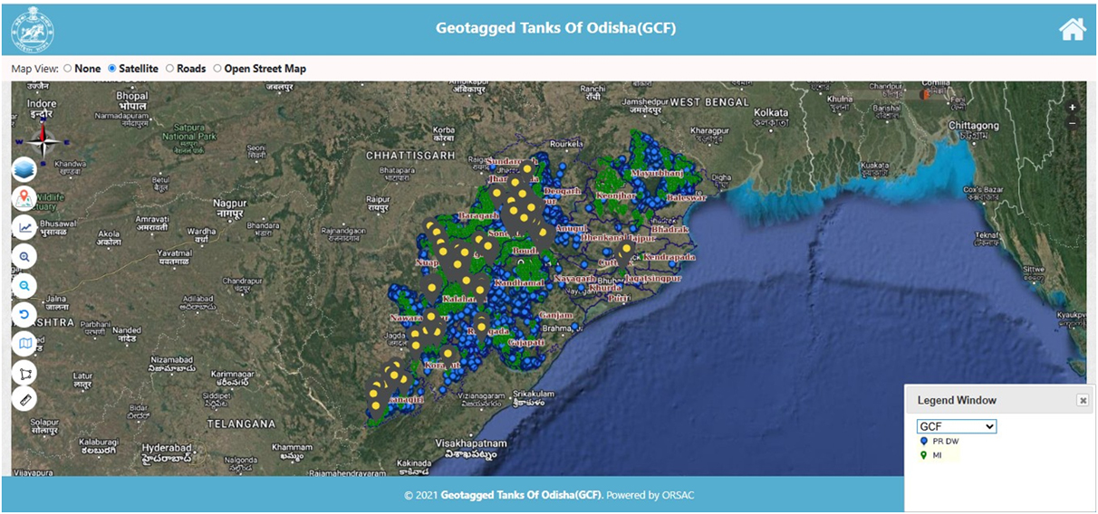
536 Nos. Of Minor Irrigation projects have been identified for rehabilitation in 15 Districts of Odisha in 4 river basins e.g. Rushikulya, Budhabalang,
Baitarani and Tel Sub-basin covering about 56,200 Ha. These districts include Bolangir, Balasore, Bargarh, Bhadrak, Boudh, Gajapati, Ganjam, Jajpur, Kalahandi, Keonjhar, Kandhamal, Mayurbhanj, Nabarangpur, Nuapada, and Subarnapur.
ORSAC has been instrumental in developing technological solutions to facilitate the implementation of OIIPCRA. One notable contribution is the development of a mobile application designed to collect detailed information on
multiple tanks across Odisha. This application is utilized by department-assigned surveyors to conduct comprehensive surveys of tanks state-wide, aiding in effective water resource management and climate-resilient agricultural practices.
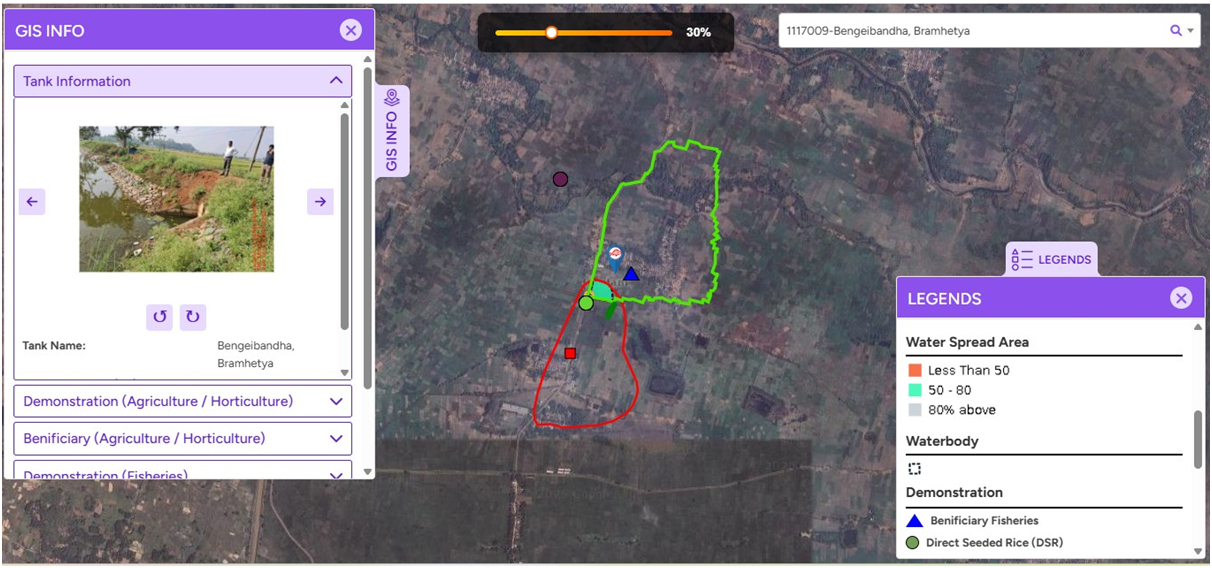
This application is designed to provide Management Information System and Decision Support System to get the details of all irrigated, cultivated lands and irrigated area of the Odisha state. Geographic Information System (GIS) Survey of Tanks,
physical work progress, financial progress and number of beneficiaries for monitoring which are coming under Odisha Integrated Irrigation Project for Climate Resilient Agriculture project using Geo tagged Images and locations on a fully Offline mode.
In GIS view Water Spread Area, Cropping Intensity based on AI/ML, Yearly Crop Status, Monthly Crop, Non-Crop. Integration of ADAPT portal, APICOL portal and etc. MIS for tender automation process. Centralized and automated Grievance Redressal Mechanism.
Contribution to GCF Initiatives:
The Application is now designed to cater to the GIS Survey of GCF (DoWR (MIPs) and PR&DW) for 10,000 (9000 from PR&DW & 1000 from MI) numbers of community tanksusing Geo Tagged Images and locations on a fully Offline mode.15 districts Bolangir,
Bargarh, Boudh, Gajapati, Kalahandi, Kandhamal, Keonjhar, Koraput, Malkangiri, Mayurbhanj, Nuapada, Nabarangpur, Rayagada, Sambalpur and Subarnapur.for GCF.
This application is having survey and billing & in two flavours Mobile Application and Web Application.Mobile Application is for survey and Web Application for billing.
Development of Web-portal and container based Mobile App for Collection of additional attribute information such as (a) Tank type (M.I / PR Tank), (b) Area of Tank, (c) Ground Water Level,
(d) Maximum and Minimum tank water level, (e) Solar pump Installation, (f) No. of beneficiaries, (g) Aquatic vegetation cover in % and any other data as required.In alignment with GCF objectives,
ORSAC has developed a dedicated application to support data collection efforts. This application enables the systematic gathering of tank details across the state, ensuring accurate data collection and analysis.
Through these technological interventions, ORSAC significantly contributes to the effective implementation of climate-resilient projects in Odisha, supporting both OIIPCRA and GCF initiatives.